|
|
|
Tour:
Location of Nawiliwili Bay
|
|
|
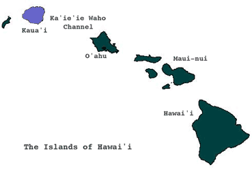 |
Kaua'i is the oldest and northwesternmost of the major Hawaiian
Islands. It is separated from the other islands by the challenging
Ka'ie'ie Waho Channel.
|
|
|
"Maika'i Kaua'i,
hemolele i ka malie."
So
fine is Kaua'i, tranquil in the calm.
|
|
|
Information about the moku 'aina
of Kaua'i and the ahupua'a of Nawiliwili Bay is based on Kauai:
Ancient Place-Names and Their Stories, and the The
Place Names of Puna, by Frederick B.
Wichman |
|
|
|
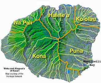
Kaua'i is divided into five major districts, or moku 'aina.
Nawiliwili Bay is located in the moku 'aina of Puna on the
southeastern coast. One meaning of puna is spring, and Puna
has an abundance of springs and streams caused by its location
on the windward side of the island. Around 1000 A.D., settlers
from the Marquesas arrived, led by Punanuikaia'aina. He succeeded
in creating a chiefdom independent of Kona in Puna.
|
 |
|
Map courtesy of Ho'okipa Network
|
|
"He nani
wale no o Puna mai 'o a 'o."
There
is only beauty from one end of Puna to the other.
There is nothing to complain
about.
Olelo No'eau #838
|
|
|
|
|
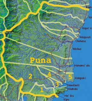 |
An ahupua'a is a Hawaiian
land division within the moku 'aina, usually extending from
the uplands to the sea. The five ahupua'a of Nawiliwili Bay
are located in the southern section of Puna. They are:
1.
Kipu
2.
Ha'iku
3. Niumalu
4.
Nawiliwili
5. Kalapaki
Aerial photographs of the ahupua'a of Nawiliwili Bay courtesy
of photographer David Boynton and pilot Casey Riemer of Jack
Harter Helicopters. Mahalo.
|
|
Map courtesy of Ho'okipa Network
|
|
|
|
These are the ahupua'a of Nawiliwili
Bay. In the next section of our tour, we will ask why they are
'ainakumuwai, or the source of our streams. |
|
|
|
|
|
|
|