|
|
|
Natural
History: Island Formation
|
|
|
|
 |
In this section we will
examine the forces that built and changed Kaua'i. You will hear
words like hot spot, shield volcano, formation, caldera, collapse
crater, landslides, breccia, columnar basalt, alluvium, depression
and erosion. By the time we are through, you should know what
they mean, and be able to apply them to the ahupua'a of Nawiliwili
Bay. |
|
|
|
|
|
|
|
This section of 'Ainakumuwai
draws text and photos from Hawai'i Natural History Association's
Geology of Hawaiian Volcanoes web site and from
Volcanoes in the Sea - The Geology of Hawai'i by Gordon
A. Macdonald and Agatin T. Abbot. Information was also drawn
from Kaua'i's Geologic History by Chuck Blay and Robert
Siemers; and finally, Peter Reiner's website The Structure
and Growth of the Island of Kaua'i. |
|
|
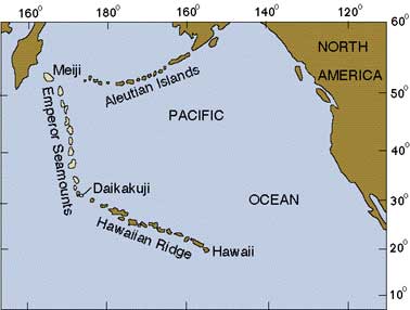
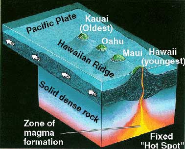
Although Kaua'i is the oldest of the eight major Hawaiian
Islands, it is a younger member of the Hawaiian-Emperor
Volcanic Chain. These islands and submerged seamounts
were formed when the Pacific Plate of the Earth's crust
moved over a hot spot below it. About 40 million years
ago, the Pacific Plate changed direction from north to
northwest. |
 |
|
|
We can see this at the Hawaiian- Emperor
Bend above.
|
|
|
|
|
|
|
|
|
|
|
| Mejii Seamount is approximately
80 million years old; Midway Island is 27.7 million years old;
Kaua'i is 5.1 million years old, and the Big Island of Hawai'i
is less than half a million years old. Island formation has
been occurring over this hot spot for at least 80 million years.
(Blay) |
 |
|
|
|
|
|
|
|
 |
|
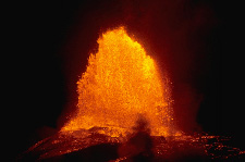
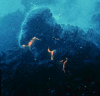
Each of these seamounts and islands
began as a submarine volcano on the ocean floor. Loihi, off
the southeast coast of the Big Island is an example of this
stage. It should break the surface in a few hundred thousand
years. To the left, underwater lava forms pillow lava, the beginning
of an island. We can see examples of pillow lava above the Menehune
Ditch in Waimea Valley. |
|
|
|
|
|
|
|
|
|
|
Above sea level, island formation
continues with thousands of far-spreading thin lava flows that
build broadly rounded, dome-shaped mountains known as shield
volcanoes. |
|
 |
|
|
|
|
|
|
|
|
|
|
|
|
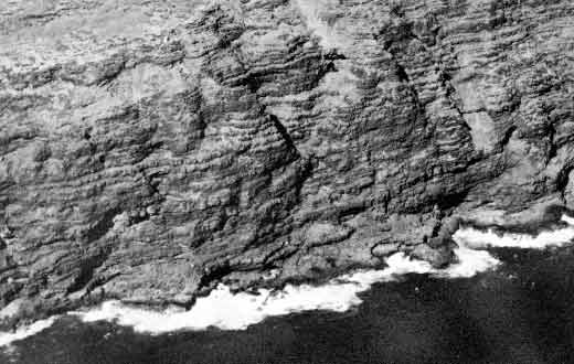
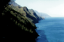
Above is a cross section of the many
thin lava
flows that made the Kaua'i Shield Volcano
5.1 million years ago. These narrow layers are
tilted towards the lava vent that produced them,
and are known as the Napali Formation.
Photo by Agatin T. Abbot Used with permission. |
|
|
|
|
|
|
|
|
|
|
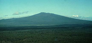
To the right is Hualalai, on the
Big Island. A young Kaua'i may have resembled this shield volcano
before landslides, shield collapse, erosion and later eruptions
altered her innocent face. |
|
|
|
|
Geologist Peter Reiner's latest research
indicates that Kaua'i may have actually been formed by two shield
volcanoes. Check his website link in Sources and Credits for
details. |
|
|
|
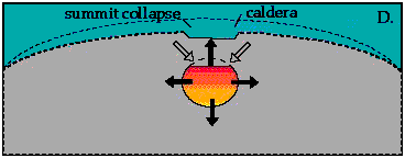 |
During shield building, calderas
may form when the top of the shield collapses as the magma (underground
lava) beneath it moves away. |
|
|
|
|
|
|
|
|
|
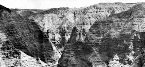
When collapsed calderas are filled
with new lava, it ponds in horizontal layers that cool much
slower than shield flows; this makes them thicker and more resistant
to erosion. Visible above are horizontal layers that filled
the caldera formed at the top of the Kauai shield. These layers
are part of the Olokele Formation, exposed in Po'omau Canyon
by the river's erosion. Photo by Agatin T Abbot
Used with permission. |
|
|
|
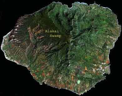
| The caldera at the top
of Kaua'i's shield volcano is 10-12 miles across, the largest
in the Hawaiian Islands. It was filled in by the later Olokele
Formation to form one of the higher bogs (high rainfall, limited
drainage, no porous soil) on Earth, the Alakai Swamp. |
 |
|
|
|
|
|
|
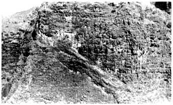 |
This is a picture of the caldera's
border. On the left are the thin layers of the Napali Formation.
They are separated from the thick and horizontal Olokele Formation
on the right by a diagonal layer of breccia (mass of rock fragments). |
|
|
|
|
|
|
|
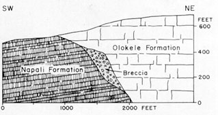
Here is a diagram of the same picture, showing the different
layers
Photo and diagram by G. A. Macdonald (Geology and Ground-Water
Resources of the Island of Kaua'i)
|
 |
|
|
|
|
|
 |
|
On the east side of Kaua'i, the Lihu'e
Depression was thought to be a collapse in the Napali Formation.
Three and a half million years ago, the lava of the Koloa Volcanics
began to cover the floor of the Lihu'e Depression. The last eruption
of the Koloa Volcanics Series was half a million years ago in
Wailua. |
Sleeping Giant (Nonou) and Kalepa
Ridge are
remnants of the Napali Formation |
|
|
|
|
|
Geologist Peter Reiners says,"
These lavas [the Koloa Volcanics] have very strange and interesting
compositions, and commonly bring up pieces of mantle rock from
very deep within them when they erupt. In the Lihu'e basin they
extend down some 1200 feet below sea level, suggesting that
something pretty strange might have happened in this region
quite awhile ago." We can see the thick horizontal ponded
layers of the Koloa Volcanics at the top of Opaeka'a Falls . |
|
|
|
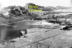 |
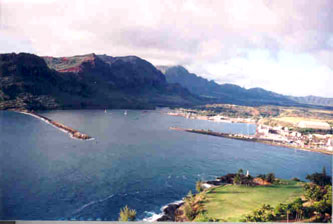
At the southern border
of the Lihu'e Depression is the Ha'upu Caldera, and its associated
ridge. The ridge is part of the Napali Formation of the original
Kaua'i Shield, while the Ha'upu Caldera is really the remains
of a ponded lava plug that filled the original caldera about
the same time as the Alakai Swamp was formed. The erosion resistant
horizontal layers of this plug are clearly visible, and are
known as the Ha'upu Formation. |
|
|
|
|
|
|
|
| That the Ha'upu Formation
did not mark the vent of an independent volcano is shown by
the fact that the lava beds around it do not slope away from
it, but continue to slope away from the center of the island.
(G.A. Macdonald) The golf course in the foreground
is on the lava of the Koloa Volcanics. |
|
|
|
|
Photo by Randy Wichman
|
|
|
|
|
|
|
|
|
|
|
|
|
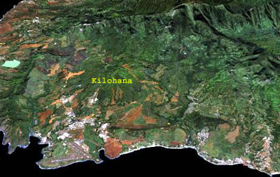 |
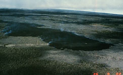
Kilohana, a small shield volcano, was also created by the Koloa
Volcanics. Visible at its top is a collapse crater, too small
to be called a caldera. |
|
|
|
|
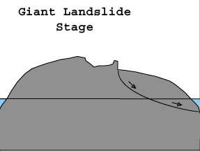
Another factor involved in changing
the face of Kaua'i is landslides. In the 1980s, the US Geological
Survey used sonar to map the sea floor surrounding the Hawaiian
Islands. Geologists discovered about 70 major giant landslides
that cover half of the flanks of the Hawaiian Ridge (Moore
and others, 1989; 1994) |
 |
|
|
|
|
|
|
|
|
 |
Kauai has two or three major landslide
areas. On the north shore, the landslides helped to shape the
steep Napali cliffs.. On the south shore, the slide was a part
of the slump known as the Makaweli Depression. By redirecting
the flow of streams, the Makaweli Depression was responsible
for the erosion of the Waimea Canyon. On the east side, a slide
may have been part of the collapse that created the Lihu'e Depression.
|
|
|
|
|
|
|
|
|
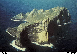
Other destructive forces constantly
changing Kaua'i are erosion and island subsidence (sinking).
In about two to three million years, these forces will reduce
Kaua'i to the size(one mile long, 900 feet high) of Nihoa, the
next Hawaiian island to the northwest. |
|
 |
|
|
|
|
|
|
|
|
|
|
|
|
|
 |
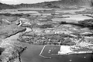
Why don't the ahupua'a of Nawiliwili Bay have deeply eroded
valleys like those of the Napali cliffs? There are two main
reasons.
Photo by Peter Reiner |
|
|
|
|
|
|
|
First, any deep valleys on the east side that formed in the
original shield were lost in the collapse that created the Lihu'e
Depression. Second - after the collapse, streams had to cut
and recut their valleys as a series of Koloa Volcanics lava
flows filled in their earlier erosive effort. |
 |
|
|
|
|
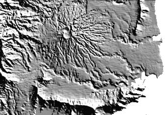 |
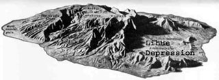
This relief model displays clearly
the valleys cut by Hule'ia, Pu'ali, and Nawiliwili streams. Note
the radial stream erosion surrounding Kilohana. In addition
to carving their valleys, these streams also carried the alluvium
(eroded material) and deposited it along the base of the Ha'upu
Ridge, as well as the lower reaches of each stream, enriching
the valley soil for agriculture. |
|
|
|
|
|
|
|
|
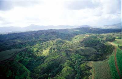
Here's what radial stream erosion on Kilohana really looks like. |
|
 |
|
|
|
|
|
|
|
Photo by David Boynton, pilot Casey
Riemer of Jack Harter Helicopters. |
|
|
|
 |
|
Lava at Nawiliwili has some very special qualities. A form of
lava that cooled very slowly in dikes (rock formed when magma
is forced into a crack and cools there) is called columnar basalt.
|
|
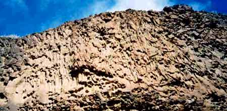
As it slowly cools, columnar basalt
separates into columns of four, five, or six sides. We can see
this lava behind the dock at Nawiliwili, or while surfing
puka moi at Kalihiwai. Above, the small columnar basalt
at Nawiliwili Bay. |
|
|
|
|
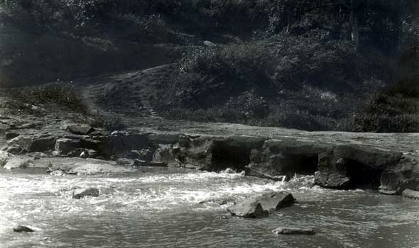
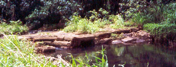
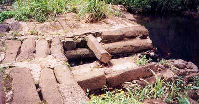
| A really unique columnar
basalt was quarried (excavated) in Kipu, and can be seen in
a bridge built in the early 1900's, over the Hule'ia River.
There is no other bridge like this in the islands A corral was
built of the same material on the ranch. (Hobey) |
|
 |
|
|
|
|
|
 |
|
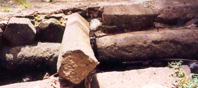
It is the size of the columns that is so remarkable. This dike
rock was important for the fabrication (making) of tools |
|
|
|
|
This bridge was built so that the children of the workers at
Kipu could go to school in Hule'ia. Before the stone bridge,
a Hawaiian trail went through here to the fishing grounds at
Kipu Kai. |
 |
|
|
|
|
Photo courtesy of the Baker Collection,
Kaua'i Historical Society. The Rice Bridge
|
|
|
|
The next time you travel around the
ahupua'a of Nawiliwili Bay - try look. You will see the evidence
of island formation all around you. Once Kaua'i was born, native
plants arrived and began a slow change into species found
nowhere else on the planet. |
|
|
|
|
|
|
|
|
|