|
|
|
|
 |
|
The General Plan states the County's 20-year vision for Kaua'i.
Multiple agencies are responsible for implementing this plan:
the Planning Commission, County Council, Planning Department,
Public Works, State Board of Land and Natural Resources, and
the State Commission on Water Resource Management. Sound familiar?
Who has the mauka to makai view? In this section
we look at the changes planned for the ahupua'a of Nawiliwili
Bay. What will be the effect of these changes?
|
|
|
General Plan map
|
|
|
|
|
|
|
|
|
|
|
|
|
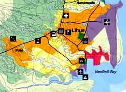
Let's take a closer look at the map
of planned changes for Lihu'e. |
|
|
|
|
|
|
|
|
|
|
The County's new strategy is to focus growth around a main
Urban Center.
An urban center permits uses like commercial and industrial.
New urban development will extend south to Puhi, and north
to Hanama'ulu Valley. The Lihu'e Plantation lands at Kilohana,
recently purchasd by Grove Farm, continue their agricultural
designation.
|
|
|
|
Also
in the works are Residential Communities, a golf course, and
new roads in the ahupua'a of Niumalu. The residential communities
and golf course are all projects of Grove Farm, which was recently
bought by Steve Case, founder and CEO of America On Line (AOL).
Check out the map of their plans below. |
|
|
|
|
 |
|
The legend tells it all.
The former sugar lands of Grove Farm are being developed for
urban use, residential communities, and golf courses. Pu'ali
Stream's valley, the darkest color on the map, runs through
the middle of this proposed development. On the edge of Hule'ia
Valley is Grove Farm's Hulemalu Plateau, newly designated as
a Residential Community by the General Plan. When it rains,
what will the water carry to the streams? |
|
|
|
|
|
|
|
|
|
|
 |
|
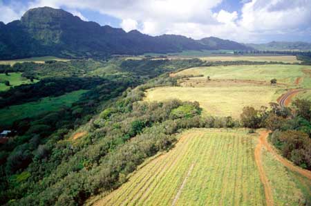
The view from the Hulemalu Plateau, newly designated as a
residential community by the General Plan.
|
|
|
|
|
|
|
Photo by David Boynton, pilot- Casey Riemer
of Jack Harter Helicopters
|
|
|
|
|
Presently approved for Grove Farm,
but not yet developed, are the Regency Assisted Care Facility
for the Elderly, the YMCA complex, and the Kukui Grove West
Village Commercial Expansion. With the purchase of Lihue Plantation's
lands at Kilohana, Grove Farm has become the major player in
the ahupua'a of Nawiliwili Bay. |
|
|
|
|
|
| What are the possible
effects of the General Plan on the
ko kaha kai , the kula,
and the wao akua?
As with the Hawaiian settlers, the wao
akua is relatively untouched. The
kula, once lowland dry and mesic forest
- cleared for Hawaiian agriculture - stripped for sandalwood,
firewood, and degraded by introduced animals - cleared for sugar
cultivation - will become an urban center and residential communities. |
|
 |
|
|
X marks a primo lot in Grove Farm's future
Niumalu Overlook Subdivision.
Photo by David Boynton, pilot- Casey Riemer of Jack Harter
Helicopters
|
|
|
|
|
|
|
|
|
|
|
|
 |
|
The ko kahakai
is our coastal zone. It includes our beaches, muli wai
(estuary), wetlands, and coral reefs. Traditionally, this area
was a sustainable resource for aquaculture, fishing, and kalo
cultivation. The muli wai is a habitat for many salt
and freshwater fish, as well as native birds. The muli wai
serves as a buffer and filter between the land and ocean. |
|
|
Photo by Randy Wichman
|
|
|
|
|
|
|
The kaha kai
is important to our quality of life and our health for reasons
other than jobs, healthy economies, and recreational opportunities.
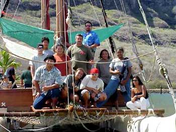
Nawiliwili Bay serves as the focal
point for community life and traditions, hosting
everything from watershed festivals to the Hokule'a. |
|
 |
|
|
|
|
|
|
|
Kawika's students from Kauai High visit
the Hokule'a during her last visit to Nawiliwili.
Photo by Dennis Chun
|
|
|
|
|
|
|
|
|
|
|
The effect of the General
Plan on the kaha kai
depends on how development in the
kula proceeds. What
happens in one part of the ahupua'a affects all the others.
We know that water quality is bad in Nawiliwili Bay. How bad?
To find out, we need an assessment. |
|
|
|
|
|
|
|